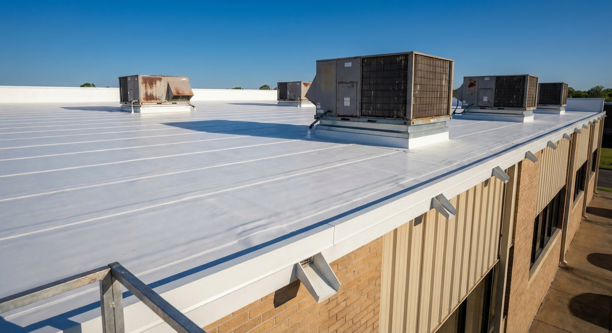
Why We Fly Big Knoxville Roofs Instead of Walking Them
The problems that drive a reroof decision on a large low-slope roof almost never sit on top of the membrane where a person on foot can spot them. They sit underneath it, in saturated insulation, and they hide in the broad low areas of a roof you would need most of a day to walk. On a fulfillment building off Lonas Drive or a manufacturing roof in the Forks of the River Industrial Park, a clipboard walkover is slow, incomplete, and it puts a crew on a membrane whose condition nobody has confirmed yet. We fly those roofs. A drone carrying a high-resolution camera and a radiometric thermal sensor records the entire field, captures every drain sump, seam, curb, and penetration, and never sends a boot across a sheet that might already be fragile.
That second point carries real weight. Foot traffic on an unknown roof is both a liability and a way to bruise a membrane that is barely holding. An aerial pass lets us read the roof before anyone climbs on it, then place a technician only at the specific spots that warrant a hands-on look. We use the same approach across the retail rooftops out toward Turkey Creek, the office and institutional buildings ringing downtown Knoxville and the University of Tennessee, and the warehouse stock lining the I-40 and I-75 freight corridors. Wherever a roof is large and flat, flying it beats walking it on speed, on safety, and on how much it actually finds.
The Infrared Sensor Is the Part That Earns Its Keep
The single most valuable product of a drone inspection on a low-slope commercial roof is a moisture map, and that comes from the thermal camera rather than the visible-light one. The physics is simple. Wet insulation soaks up the day's solar heat and holds onto it longer than the dry insulation around it. After sunset, as the whole roof radiates its heat back to the night sky, the saturated zones stay warmer and light up against the cooler dry field on the infrared image. That contrast reveals the location and reach of trapped moisture inside the assembly even when the membrane on top looks flawless from above.
Timing makes or breaks a thermal flight. We fly in the cool-down window after sunset, on a day that built up enough solar gain under a clear enough sky for the contrast to form, and we stay off the roof right after rain when surface water drowns the readings. Knoxville's humidity actually works in favor of the diagnosis, because trapped moisture is so common in roofs here, but it also means we choose our flight conditions deliberately. Once the thermal anomalies are mapped, we verify a handful of them with core cuts at the flagged spots instead of trusting the image alone. That moisture map is what answers the real question: target the wet zones for cut-out and recovery, or replace the roof if saturation has spread too far to chase. Spec a roof without it and you are guessing.
Storm Documentation an Adjuster Will Accept
After a hailstorm or a high-wind event rolls through East Tennessee, how fast and how cleanly you document the roof often decides how the claim lands. We deliver GPS-tagged, date-stamped imagery an adjuster can work through remotely, covering hail-impact density across the field, wind-lifted or displaced membrane, and damage to rooftop units and flashings. Because every frame carries its own coordinates, there is no argument about where a given defect lives on the roof. We build the package in the format commercial property carriers expect, so it drops straight into the claim file without rounds of back-and-forth, and for storm work we move the flight up the schedule to capture conditions while they are fresh.
Tighter Bids and Fewer Mid-Project Surprises
Drone work is not only diagnostic. Before we put a reroofing proposal together, an aerial survey gives us accurate roof-area takeoffs, pinpoints every penetration and curb, and records existing conditions against the as-builts. A specification drawn from measured reality instead of assumptions cuts down the RFIs and change orders once a crew is on the roof, because we are not discovering an unexpected curb or a miscounted drain in the middle of a tear-off. For an owner running several buildings, it also produces one consistent, comparable baseline across the whole portfolio.
Flying Legally and Safely Over Knoxville
Commercial drone flights are regulated, and we run ours by the book. Every flight is conducted under FAA Part 107 by a certificated remote pilot, and we account for the airspace picture here, which matters in Knoxville because of proximity to McGhee Tyson Airport and the smaller general-aviation fields scattered around the region. Where a roof falls inside controlled airspace, we secure the required authorization before the aircraft leaves the ground, not after. On site, we keep the drone within visual line of sight, brief the property on the flight window, and avoid flying directly over people or active loading lanes. Operating safely and legally is part of the job, not a footnote to it.
Common Questions About Drone Roof Inspection in Knoxville
Why is a drone better than someone walking the roof?
It covers the whole surface systematically from a consistent altitude, produces a complete photographic record, and does it with no foot traffic to bruise a fragile membrane or put a worker on an unconfirmed roof. On a large flat roof a walkover burns hours and still skips the low, hidden areas. And thermal moisture mapping simply is not practical on foot at scale, which is the part that finds the problems that actually matter.
Can infrared really see moisture under the membrane?
Yes, in the right conditions. We fly the thermal pass during the post-sunset cool-down, when wet insulation that banked the day's heat reads warmer than the dry field around it. The resulting map is accurate enough to drive the choice between partial cut-out and full replacement. We confirm the flagged areas with core cuts so the specification rests on verified findings rather than the image alone.
What does the inspection give us for an insurance claim?
A GPS-tagged, date-stamped report documenting hail-impact locations and density, wind-damage patterns, and damage to equipment and flashings, assembled in the format commercial carriers expect and ready to hand to the adjuster. Because each image is geolocated, there is no dispute over where a defect sits on the roof.
Large, flat, low-slope commercial roofs: distribution and industrial buildings, retail centers, office complexes, and multi-building campuses. On small or steep roofs a manual look is quick and complete, so the drone edge shrinks. For any commercial roof beyond roughly 10,000 square feet that needs a genuine condition assessment, flying it is the more thorough and efficient route.
Are you authorized to fly commercially?
Yes. Flights run under Part 107 with a certificated remote pilot, and we obtain controlled-airspace authorization where it is required given the proximity to McGhee Tyson and regional airfields. We keep the aircraft in visual line of sight and stay clear of people and active operations.
Schedule a Knoxville Roof Inspection
Whether you need a moisture survey to settle a repair-versus-replace question, storm documentation for a claim, or accurate existing conditions ahead of a reroof, an aerial and thermal inspection is the efficient place to begin. Reach out and we will get a flight on the calendar and walk you through the report once it is ready.